How Was Wulingyuan Formed? Uncovering the 380-Million-Year Mystery of China’s “Avatar Mountains”
When you first stand before the thousands of stone peaks in Wulingyuan, one question naturally comes to mind: how was Wulingyuan formed? These towering quartz-sandstone columns look almost too magical to be real—and in a way, they are. This is nature’s masterpiece, a story written over 380 million years. Let’s travel back in time and explore exactly how was Wulingyuan formed by Earth’s most patient sculpting forces.
The Story Behind the Name: Wulingyuan
Before diving into the geology, let’s talk about the name. “Wuling” comes from the Wuling Mountain Range, a massive mountain system stretching across Hunan, Hubei, Chongqing, and Guizhou. In the ancient Tujia language, “Wu” suggests martial arts, and “Ling” means mountains—together evoking the image of towering, powerful peaks.
The name “Wulingyuan” itself has poetic roots. Over 1,600 years ago, poet Tao Yuanming wrote “Peach Blossom Spring,” a famous tale about a fisherman from “Wuling” who stumbles upon a hidden utopia. Later, poets like Li Bai and Wang Wei used “Wulingyuan” to describe an ideal, mystical land.
Fast forward to 1984. Back then, three scenic areas—Zhangjiajie National Forest Park, Tianzi Mountain, and Suoxiyu—were managed by separate counties, leading to constant disputes over borders and development. The famous painter Huang Yongyu proposed merging them under the poetic name “Wulingyuan.” The suggestion stuck. In 1985, then-leader Hu Yaobang personally inscribed the name, and in 1988, Wulingyuan District was officially established. Just four years later, in 1992, UNESCO recognized its global value, listing wulingyuan national park china as a World Heritage Site.
The Geological Story: A 380-Million-Year Journey
So, how was Wulingyuan formed? Imagine it as a four-act drama, with each act lasting millions of years. Understanding how was Wulingyuan formed requires looking beneath the surface—literally—at the rocks that make this place so extraordinary.
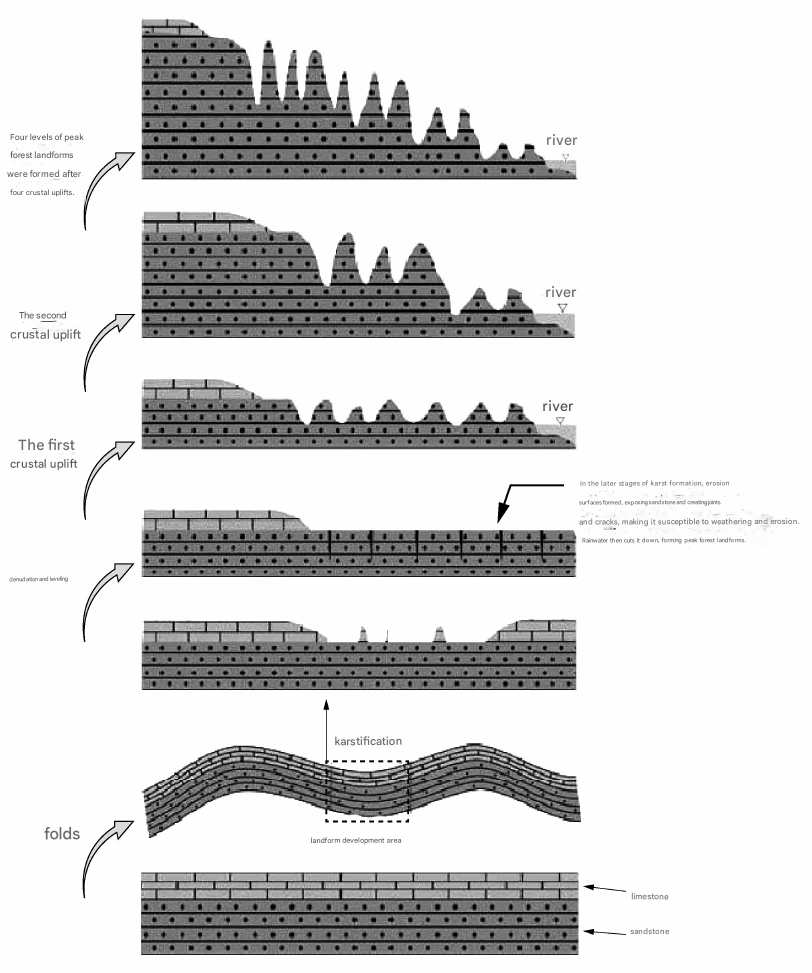
Act One: The Ancient Seabed (Around 380 Million Years Ago)
Picture this: 380 million years ago, during the Middle and Late Devonian period, there were no mountains here. Instead, Wulingyuan was a shallow sea near a coastline. Just like rivers today carry sand and sediment into the ocean, ancient rivers continuously deposited layers of sand onto this seabed. This is where the story of how was Wulingyuan formed truly begins.
This process continued for tens of millions of years. Layer upon layer of sand was buried, compressed, and cemented over time. The result? A massive quartz-sandstone formation, hundreds of meters thick. This rock is incredibly hard, composed mainly of quartz grains tightly bonded together. Think of it as a giant, dense “stone cake” over 600 meters thick—the raw material for the future forest of peaks. To really grasp how was Wulingyuan formed, you have to appreciate this foundational layer.
Here’s a quick look at the rock layers beneath Wulingyuan:
Top Layer (once there): Permian limestone (100-200m thick) – mostly eroded away now.
Main Layer: Yuntaiguan Formation quartz-sandstone (up to 600m thick) – purple-red to grey-white. This is the star of the show.
Middle Layer: Huangjiadeng Formation siltstone (0-30m thick) – a thinner layer.
Base Layer: Silurian shale (up to 1000m thick) – a softer foundation.
This specific “limestone on top, sandstone in the middle, shale at the bottom” structure was crucial for everything that followed. Scientists studying how was Wulingyuan formed point to this layering as essential to the unique landscape.
Act Two: Uplift and Fracturing (Around 150 Million Years Ago – Recent Past)
Between the Jurassic and Neogene periods (roughly 150 million to a few million years ago), intense tectonic movements—geologists call them the Yanshanian and Himalayan orogenies—began reshaping eastern China. The Earth’s crust here was pushed upward in stages. But instead of rising smoothly, it cracked. The question of how was Wulingyuan formed now enters its most dynamic phase.
Imagine pressing on a thick cookie. It doesn’t crumble into dust; it breaks along specific lines. Similarly, these tectonic forces created a network of vertical joints and fractures within the massive quartz-sandstone block. Three main sets of these natural cracks developed, intersecting each other and carving the solid rock into countless individual blocks.
These vertical joints are the secret behind the peaks. They became pathways for water and zones of weakness, predetermining where future valleys and towers would stand. Any explanation of how was Wulingyuan formed must highlight these fractures—they are the blueprint for every pillar you’ll see.
Act Three: Carving by Water (From About 5 Million Years Ago to Today)
Starting around 5 million years ago (late Neogene), the real sculpture work began. This is the chapter that definitively answers how was Wulingyuan formed into the landscape we see. Think of water as the sculptor’s chisel:
Stage 1: The Platform – First, the crust stabilized for a while. Rivers eroded the surface down to a relatively flat plain at 1100-1300 meters altitude. Geologists call this the “Xiangxi period planation surface.”
Stage 2: Table Mountains and Stone Walls – Then, the crust started lifting again. Rivers cut down along those vertical joints, carving the flat land into giant blocky “table mountains” and ridge-like stone walls.
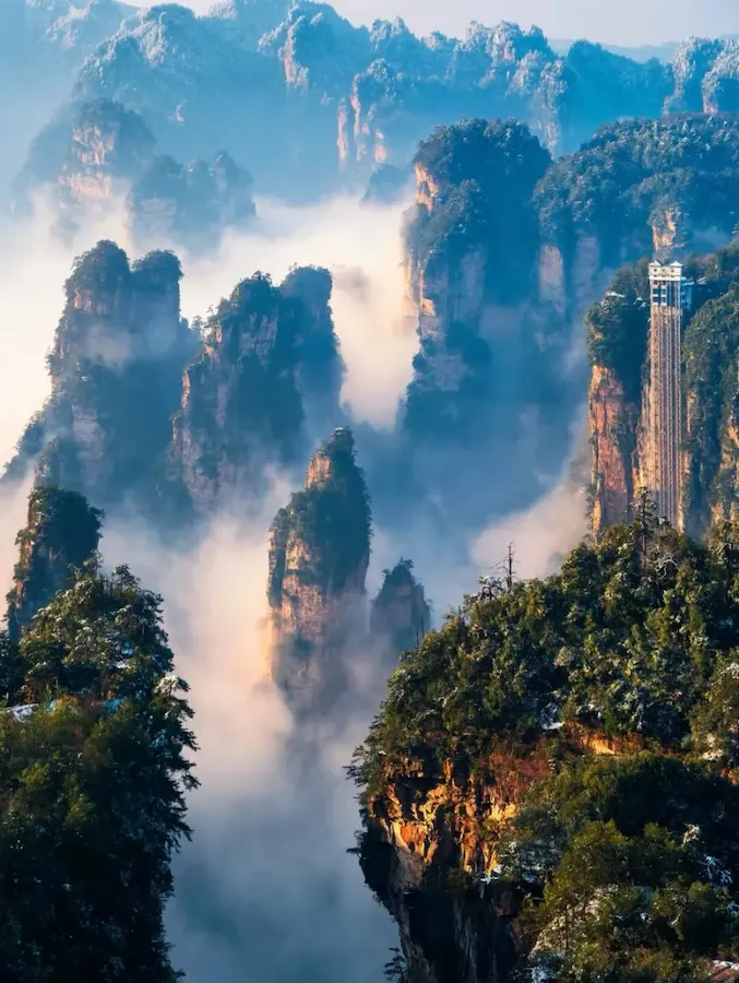
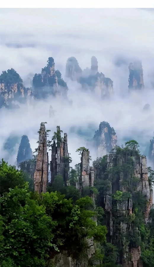
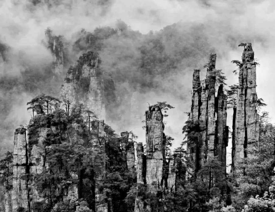
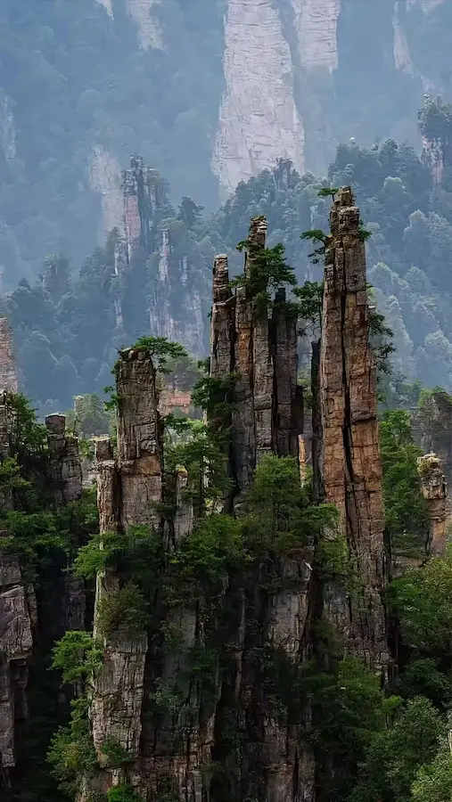
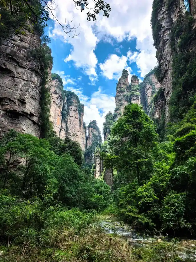
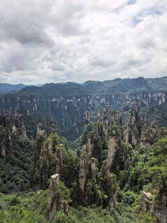
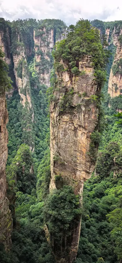
Stage 3: The Peak Forest – Continued uplift made rivers cut deeper. The network of streams grew denser. Water widened the joints, and gravity pulled blocks loose along the cracks. The table mountains and walls were further dissected, slowly transforming into the independent stone peaks and pillars we see today—like the famous Golden Whip Rock or the Avatar Hallelujah Mountain. This stage most clearly shows how was Wulingyuan formed through persistent water erosion.
Stage 4: Old Age – In some areas, like parts of Suoxiyu, the landscape has entered a more mature stage. Erosion is gentler, peaks are lower and fewer, and river deposits are more common.
Geologists have identified a full life cycle for these peaks: Fracture valley → Erosion platform → Table mountain/stone wall → Stone pillar → Remnant peak. The magic of wulingyuan national park china is that you can see all these stages in one visit!
Act Four: The Fine Details – Weathering and Collapse
While rivers did the heavy lifting, other forces added the fine details to complete the picture of how was Wulingyuan formed:
Weathering: In this climate, water seeps into cracks. When it freezes in winter, it expands, acting like a tiny wedge (frost wedging). Daily temperature changes also make the rock expand and contract, slowly loosening the surface.
Gravity Collapse: As river cuts deepened, the bases of some pillars were undercut. Gravity pulled massive blocks down along the joint planes, creating sheer cliffs and bizarre shapes. Look at the base of many pillars—you’ll often see piles of collapsed rock, evidence of this process.
Cave Creation: Below the sandstone, where limestone exists, groundwater slowly dissolved it, creating caves like the famous Huanglong Cave. This adds another layer of wonder to the landscape.
How to Experience This Geologic Wonder: A Practical Guide
After exploring the science of how was Wulingyuan formed, you’ll probably want to experience it yourself. Here’s how to plan your zhangjiajie tour.
Must-See Spots and What to Look For
1.Zhangjiajie National Forest Park (Yellow Stone Village & Golden Whip Stream)
Yellow Stone Village (Huangshizhai): This peak-top platform sits at 1080 meters. Walk the 3.8km trail (2-3 hours) for breathtaking panoramic views. It’s the perfect place to understand the “planation surface” concept and see hundreds of peaks laid out before you.
Golden Whip Stream (Jinbianxi): This 10+ km valley walk lets you get up close to the geology. Follow the stream and see how it flows right along those vertical joints. Golden Whip Rock, a 350-meter pillar, is a textbook example of a stone pillar isolated by stream erosion. Don’t miss the nearby Avatar Hallelujah Mountain (also called Southern Sky Column).
2.Tianzi Mountain Nature Reserve
Above 1200 meters, Tianzi offers incredible layered views. Spots like Imperial Writing Brush and Fairy Presenting Flowers showcase the results of weathering and collapse. A cable car makes the ascent easy, or you can hike (about 2 hours up).
3.Suoxiyu Nature Reserve
This area includes Ten-Mile Gallery, a 5km valley where you can see peaks at various evolutionary stages—from walls to pillars to remnants. The other highlight is Huanglong Cave. This 7.5km-long limestone cave is spectacular, filled with stalactites and stalagmites. It’s a fantastic place to contrast karst (cave) formation with the sandstone peaks above. While exploring, you might also want to experience the zhangjiajie national park glass bridge for a different perspective.
4.Yuanjiajie
Home to the famous First Bridge Under Heaven, a natural stone bridge spanning about 50 meters between two peaks. It’s a dramatic result of rock collapse. The Lost Soul Platform also offers stunning, dizzying views of the peak forest. For thrill-seekers, the glass bridge at zhangjiajie grand canyon provides an unforgettable experience high above the canyon floor.
Suggested 3-Day Itinerary
Day 1: Golden Whip Stream + Yellow Stone Village
Morning: Enter through the Wulingyuan ticket station. Hike Golden Whip Stream (2-3 hours). Look closely: See how the stream follows rock fractures? Notice the collapsed boulders at the base of cliffs? Spot Golden Whip Rock and the Avatar Hallelujah Mountain.
Afternoon: Take the cable car up Yellow Stone Village. Walk the loop trail. From up here, you’re standing on an ancient erosion surface, looking out at the peaks carved below it.
Evening: Stay overnight in Wulingyuan town (Suoxiyu Town).
Day 2: Yuanjiajie + Tianzi Mountain
Morning: Take the Bailong Elevator up to Yuanjiajie. (Fun fact: this elevator basically uses a massive vertical joint to access the top!) Explore the Lost Soul Platform and the First Bridge Under Heaven.
Afternoon: Use the park’s shuttle buses to reach Tianzi Mountain. See Imperial Writing Brush and Fairy Presenting Flowers. Descend via cable car.
Evening: Stay overnight in Wulingyuan town.
Day 3: Ten-Mile Gallery + Huanglong Cave
Morning: Walk or take the small train through Ten-Mile Gallery. Observe the different shapes of the peaks—can you spot younger pillars versus older, more eroded ones?
Afternoon: Visit Huanglong Cave (allow ~2 hours). Explore its four levels and appreciate how water dissolving rock creates a completely different landscape from the water cutting rock you saw above ground. Before leaving, consider visiting the famous zhangjiajie glass bridge in china if time permits.
Evening: Take a bus to Zhangjiajie city or the airport (about 40 minutes).
Practical Tips for Your Visit
Best Times to Visit: Spring (April-May) and Autumn (September-November) offer pleasant weather and higher chances of seeing magical sea-of-clouds views. Summer is rainier, but just after rain, the peaks emerge from mist in the most ethereal way. Winter snow paints everything white, but trails can be slippery.
Getting There:
By Air: Zhangjiajie Hehua International Airport has flights connecting to major Chinese cities (Beijing, Shanghai, Guangzhou, Xi’an) and international ones like Seoul and Bangkok.
By Train: Zhangjiajie Railway Station has high-speed trains to Changsha (~2.5 hours) and Guangzhou (~6 hours).
Park Entry: The entrance fee is 228 RMB (approx. 32 USD) and is valid for 4 days. This includes the internal shuttle buses that connect different scenic areas.
What to Pack:
Sturdy hiking shoes: There are many steps, and they can be slippery when wet.
Rain gear: Mountain weather is unpredictable. A sudden shower can appear even on a sunny morning.
Water and snacks: You can buy supplies inside, but prices are a bit higher.
Camera: Sunrises, sunsets, and sea-of-clouds days are pure magic.
Pro Tips for Geology Fans:
Look for vertical stripes on rock faces—those are old water courses following joints.
Check the base of pillars for piles of broken rock—evidence of gravity collapse.
Notice the different levels: The flattest areas around 800-950 meters are remnants of the ancient erosion surface.
Spot the color change: The purple-grey quartz-sandstone contrasts with the greener shale layers lower down.
Wulingyuan isn’t just a place to see—it’s a place to feel. Standing beneath a 350-million-year-old seabed, now thrust skyward into a 350-meter peak, you’re not just looking at a rock. You’re witnessing the slow, powerful artistry of our planet. It’s a reminder that time, water, and stone can create magic beyond imagination. Now that you understand how was Wulingyuan formed, every step through this ancient landscape becomes a deeper conversation with Earth itself.
So go ahead. Stand in the stream, look up at the cliffs, and let the story of Wulingyuan sink in. Your own adventure through 380 million years is waiting.